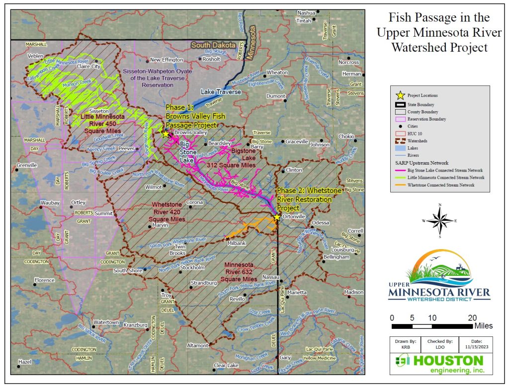
The Project area lies within the watersheds of the Little Minnesota River, Big Stone Lake and Whetstone River, which collectively cover 1,182 square miles at the Headwaters of the Minnesota River.
The Project has been split into multiple phases for ease in management of the multiple project partners which leverage the relationships of local interests. The Project will collectively reconnect the Whetstone River and Big Stone Lake with the Minnesota River and Little Minnesota River with Big Stone Lake, thus restoring fish passage from the downstream USFWS Big Stone National Wildlife Refuge on the Minnesota River to the Whetstone River, Little Minnesota River, Big Stone Lake, and all their tributaries.
Cumulatively, the multiple phases of the Project will reconnect 543 miles of the Little Minnesota River stream network, 199 miles of Big Stone Lake stream network, and 38 of the Whetstone River stream network (780 miles of upstream network total) with 9 miles of downstream network through the Big Stone National Wildlife Refuge. This is a vital fish passage connection for spring spawning in the Upper Minnesota River Watershed. The Project will significantly enhance the aquatic and riparian habitat of this regional ecosystem for more than 40 native fish species and freshwater mussel species in the Upper Minnesota River Watershed.

Phase 1 – Little Minnesota River
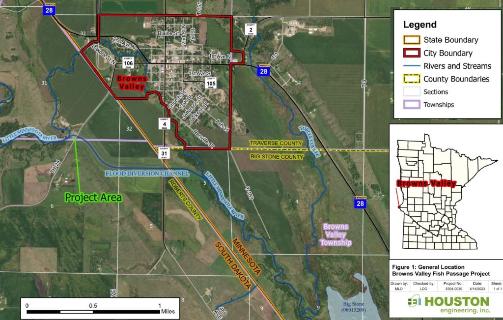
Located in Northeastern South Dakota, the Little Minnesota River is a 50-mile-long headwaters tributary of the Minnesota River. The mouth of the Little Minnesota River feeds into a narrow 26-mile-long reservoir known as Big Stone Lake. In 2010, after several major flooding events had caused significant damage to the City of Browns Valley, MN, an overflow channel was constructed along the Little Minnesota River to reroute flood waters around town and into Big Stone Lake. A levee and box culvert were installed to limit flows of water in the original channel through Browns Valley, and flood waters were redirected through an overflow channel around town.
The design has been successful in protecting Browns Valley from high flows from the Little Minnesota River, but an unintended consequence is limited fish passage during higher flow events. In 2018, the Sisseton Wahpeton Oyate (SWO) tribe initiated an assessment study with the US Army Corps of Engineers (USACE), Minnesota Department of Natural Resources (MNDNR), South Dakota Game, Fish and Parks (SDGFP), and the UMRWD to investigate existing fish passage at the Browns Valley Flood Control Project site on the Little Minnesota River. The USACE Assessment of Fish Passage determined that multiple species were negatively impacted by the 2010 flood control project including walleye, which are culturally an important species to the SWO tribe.
The UMRWD recently completed 90% design plans with input from the MNDNR, SDGFP, SWO tribe and others to incorporate design modifications to the diversion structure based off key features identified in the USACE Report to enhance fish passage to nearly 100% fish passage under all flow conditions. These modifications to the Browns Valley Flood Control Project will improve fish passage for important species including walleye (of cultural significance to the SWO tribe), lake sturgeon and Hornyhead chub (two species of greatest conservation need listed under both South Dakota and Minnesota’s State Wildlife Action Plans), among other species during critical runoff events, particularly during spring spawning season.
Phase 2 – Whetstone River Restoration
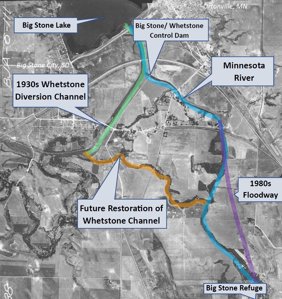
Phase 2 is located near the foot of Big Stone Lake between Grant County in Northeastern South Dakota and Big Stone and Lac qui Parle Counties, MN. Phase 2 will reestablish a connection of the Whetstone River with the Minnesota River, which will allow fish to circumvent the Big Stone Whetstone Dam.
The Whetstone River is a tributary in South Dakota which extends 35 miles into the Coteau des Prairies region. This river historically flowed directly into the Minnesota River, just south of Ortonville, MN; however, in the 1930’s a Works Progress Administration (WPA) Program project rerouted the Whetstone River directly into Big Stone Lake, bypassing the historic Minnesota River connection. The goal of the WPA project was to promote and sustain lake levels. The project abandoned the natural connection of the Whetstone River to the Minnesota River, sending all Whetstone flows into the foot of Big Stone Lake.

A 1980’s USACE Project to control high flows and manage lake levels resulted in the construction of the current dam at the confluence of the Whetstone River and Big Stone Lake. Unfortunately, these previous efforts have collectively created significant barriers for aquatic habitat and fish passage from the Minnesota River into the Whetstone River and Big Stone Lake.
Phase 2 has been a collaboration between several partners, including the UMRWD, State of MN, USFWS, MNDNR, SDGFP, East Dakota Water Development District, SWO, and the Citizens for Big Stone Lake (CBSL).
Phase 2 has been designed to permanently restore the previously abandoned historic segment of the Whetstone River channel, including reconnecting the Whetstone River to the Minnesota River. This phase will provide multiple benefits, including:
1) Improved ecological integrity of the historic Whetstone River channel;
2) Reduced flood elevations and improved water quality and habitat on Big Stone Lake; and
3) Improvements to the existing riparian corridor enhancing the movement of animal species.
Specifically, the project will accommodate fish passage, currently restricted by the Big Stone Whetstone Dam, to Big Stone Lake including all upstream waterways.