Headwaters of the Minnesota River
Big Stone Lake was formed at the end of the last ice age when glacial Lake Agassiz drained through the gap into Glacial River Warren.
The valley of that river now holds Big Stone Lake.
The Lake covers 12,610 acres of surface area, is 26 miles long and averages about 1 mile wide.
Big Stone Lake is a border water, separating Minnesota and South Dakota.
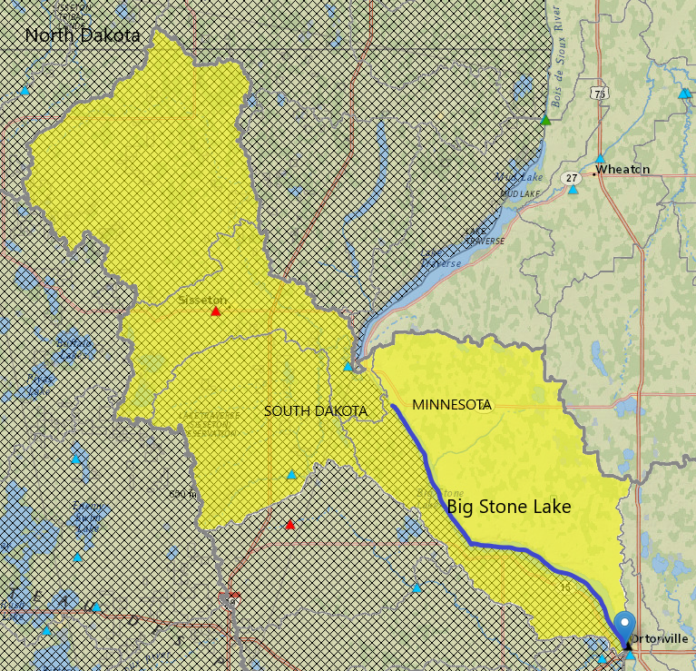
The lake’s natural watershed* (highlighted in yellow to the left) is roughly 750 square miles, extending into North Dakota, South Dakota and Minnesota.
It is the source of the Minnesota River which flows 332 miles to the Mississippi!
*Watershed is a term used for all land that flows towards the same place. PLEASE NOTE: This area does not include flows from the Whetstone River into Big Stone Lake (see section below for further explanation on the historic diversion) *
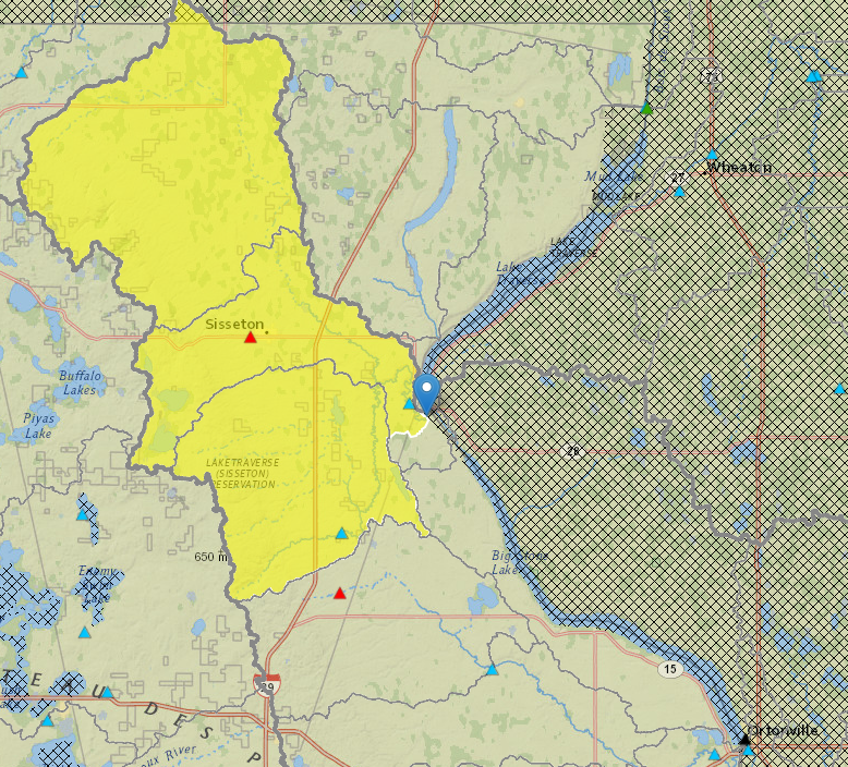
The lake is fed by the Little Minnesota River
at its north end (watershed hi-lighted to the right),
and a number of tributaries on the
MN and SD side of the lake (shown above).
There are two state parks located at the lake—Big Stone Lake State Park on the Minnesota side as well as Hartford Beach State Park on the South Dakota side. Bonanza State Park is a secondary location on the MN side, where the Bonanza Education Center is located.
Fish populations include walleye, northern pike, bluegills, crappies and perch and another 30 or so species
There are 12 public accesses on Big Stone Lake.
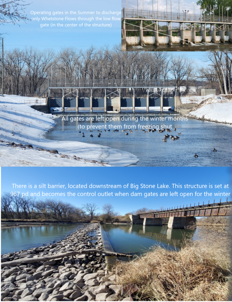
The Big Stone Lake/ Whetstone Control Structure “Dam” (pictured left) was constructed in 1987 to promote flow from the Whetstone River into the Minnesota River.
The Dam is located just south of the foot of the lake, below the confluence of the Whetstone River which flows in from South Dakota (since it was redirected in the 1930’s).
After the current Dam was constructed, locals asked to explore raising lake levels for improved water quality, to increase the lake’s drought tolerance and to provide more cover on the lake’s many rocks.
The District now operates dam gates to attain a summer pool range of 968 to 968.3* project datum (pd) on Big Stone Lake from Spring to Fall each year.
*The watershed flowing into Big Stone Lake covers an abnormally large area.
Lake levels can rise significantly after a large rain across the lake’s watershed.
Additionally, wind force can push water (and ice in the spring) higher onto shorelines throughout the year.
Lakeshore owners should take great consideration when designing shoreline protection projects as well as the placement of docks and lifts.
The historic outlet of Big Stone Lake was much lower than this newly established summer pool. In order to provide spring flood protection to homes and properties along the lake, the District lowers the lake to roughly 967 pd every fall.
The fall drawdown takes place in the month of October, allowing us to achieve winter pool before the lake freezes over.
For Questions on Dam Operations or would like the most current Big Stone Lake elevations, please contact Amber Doschadis, Dam Superintendent at 320-839-3411.
To view lake level readings, visit the Big Stone Lake Gage at this link:
National Weather Service Advanced Hydrologic Prediction Service
Click Here for MN DNR’s info page on Big Stone Lake
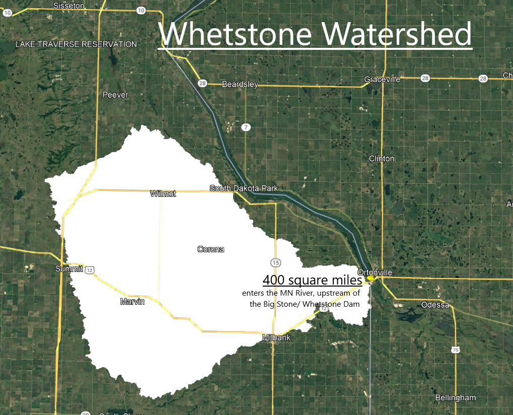
The Whetstone River Watershed is roughly 400 square miles. Historically this area flowed directly into the MN River, downstream of Ortonville, MN.
The Whetstone River was diverted in the 1930’s and currently outlets just upstream of the Big Stone Lake/ Whetstone River Dam- before entering the MN River. The initial goal of the diversion was to bring additional water into Big Stone Lake in times of drought.
As the elevation drops over 1,000 feet from the Coteau Hills to Big Stone City, SD it’s not unusual to see large increases in water come through this river system towards Big Stone Lake throughout the year.
More notably folks can see an increase in flows in the Spring, when we’re dealing with snow melting off the landscape within the frozen river.
This can cause additional flooding on Big Stone Lake, along with diminished water quality as water backs up near the foot of the lake.
(check out our Whetstone Project Page for more information on this project)